Ancient Lakes
Needed to get away. Seattle was going to be stuck under a marine layer all day, and I needed a road trip. There is a whole area between I-90 and US 2 east of the Columbia River that I’ve never been in. I left very early in the morning with a handful of printout’s of trails from the WTA and little planned, other than I was getting away for the day. While driving, I assessed that the first thing I’d come to was Ancient Lakes and headed there. Driving through vineyards and fruit groves, you eventually head down sharply to a bench, and after a longish drive down a dirt road, you arrive at a parking lot. The trial heads south out of it.
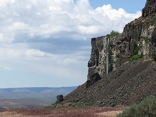
Now, I’m used to hiking in mountains and woods, and there is really only one, way to get anywhere: the trail, and it usually is not unclear which way to go because you’re following terrain. But, I’ve found that in desert hikes, that trial braids and various trails head out in different directions, and that it doesn’t matter very much which one you take. It is still unnerving to me when I don’t know where I’m going to be presented with these options, but I stuck to the one that seemed the most traveled and struck on. The trail follows a basalt cliff for the first mile or so, with waterfalls spilling over from the top, striping the gray basalt with green periodically.
Eventually you reach a massive boulder and above that is the most picturesque of the waterfalls, coming off a corner of this cliff.  After rounding the corner, you can see where you’re headed. After crossing open country, you finally encounter the ancient lakes, dug out of the desert.
Geological Elements
Time for a brief geology lesson. I knew about the channeled scab-lands in the SE corner of the state. Lake Missoula, a massive lake formed by ice dams during the last ice age. Periodically, the ice dams would fail, and the lake would drain. The massive amounts of water ultimately created the Columbia river gorge as this water desperately sought out the ocean. On it’s way there, it scraped and scourged and carved the landscape. I’d always known about Grand Coulee dam, and was aware of a coulee as geographic feature, but hadn’t really seen one, or know how they were formed. But, as the water was rushing over the high basalt plateau, it would run over a cliff and erode the cliff backwards.
This is what all waterfalls do, but the flow of water is so much slower, that these things take eons. But, with the massive amount of water, over and over again, eroded these cliffs back miles. What was left behind were these wide canyons. This process created the ancient lakes, as well as the other hikes I went on this day, but back to the lakes.
At the head of the canyon, was a nice waterfall tumbling down into the largest of the lakes. After passing a number of campers, mostly boy scouts, and skirting some lakes, you skirt the largest of them on boulders. Now, these lakes resided in the depressions left by the process described above, but that was a long time ago. Why is there water in them now? Good question. The answer is gross. All those waterfalls on the hike in, as well as these lakes, are the result of farm run-off. The water is unfit to drink, even filtered, so all these campers needed to pack all of their water in.


There is a user-made trail that climbs up along the waterfall at the head of the canyon, taking you up past a couple cataracts and into another canyon above. The trail continues up to yet another falls and the wilderness feeling is dispelled with power lines, but while standing on top of massive devils causeway like basalt at the top of the falls, you have a great view looking back the way you came and beyond to the Columbia river. Found shade beneath the only tree of any consequence and ate lunch amidst the unnerving sound of a busy hive of some sort.
Headed back out the way I came, passing cobs of overnighters. While I was in the upper canyon, the open areas around the lake began to resemble a music festival. Not a place to overnight unless you like that sort of thing, but a wilderness it is not.