Navaho Peak
Another endeavor in solitude. I’d been to a few hikes in the Teanaway (Lake Ingalls (a top 5 hike), Esmeralda Basin, Long’s Pass) and they all seemed really popular. It helps that there is a good road that slices nicely right into the heart of It. There are just so many trails in this area, that looking at the map, portions of the area resemble a city map, rather than one of a national forest. My hope, was that in the abundance, I might find a quiet niche if the trail was sufficiently long and hard enough and at around 14 miles round trip and 4,123 feet of elevation gain Navaho Peak, while no Snow Lake, was more popular than I thought.
Left the house around 7am and got to the trailhead around 9:10 and was on the trail by 9:20. Hiked in the cool morning air, mostly in shade, and the trail flew by. The grade was generally a gentle climb for the first 4 miles, until a couple switchbacks take up to a nice walk past a meadow below a striking iron red (and as far as I can tell, nameless) peak.
The trail has been following the drainage of Stafford Creek this whole time, but it is not until the junction with trail 1369 that the trail comes into contact with it. At this point, the trail heads up hill again towards Navaho Pass. You start to feel like you’re getting into high country and Earl Peak dominates the scenery to the west. After circling a meadow to the right, to avoid marching straight through it, and come to a small creek crossing brimming with Shooting Star.
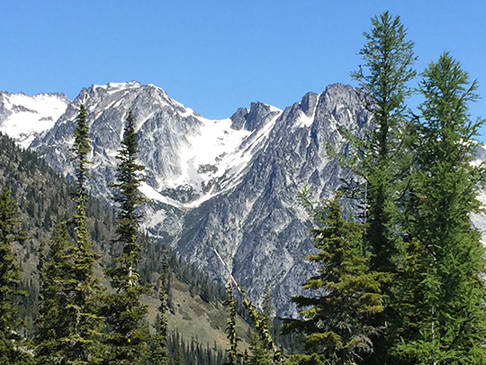
At this point, the scene changes dramatically. What had been cool forests changes into a moonscape. The trees disappear and the trail climbs steadily through emptiness. I can only assume that it was not that long ago that this area held a permanent snow field, that now is no more. I found it to be a surreal experience. One more little jog puts you at the pass with the Stuart Range spread out before you hiding, like a curtain, the Enchantment Lakes beyond.
This could be a suitable endpoint with plenty of space and scenery to occupy the senses, but the County Line trail runs along the ridge in either direction dividing Chelan County from Kittitas. Follow it east sharply uphill. The trail to the summit forks to the left while the main trail continues east, going around the summit and eventually headed down to FR 400. At this point, the views begin to open up to the south, which is why I missed the fork, and only briefly followed the main trail, before I realized my mistake.
On my way back down, I looked at the fork and I don’t know how I missed it, but to say that I was enthralled. The way up to the summit is quite steep and the rock is loose and dusty, but eventually came to the last of the snow at the summit and there it is: the summit, all of a few square yards of rock, but what a view, definitely worth the steep last mile or so up from the pass. From here, you can see all the way up the Ingalls creek valley to Mt. Stuart and Ingalls Peak to the west. Due north, great views up the valleys into the Enchantment lakes. To the south and west, Mt. Rainier and Adams were peaking from behind the haze. There was no wind, and not a bug in sight. Perfect and calm.
On the way up, I had only passed three parties. I was the first to the summit and had it to myself for about an hour. The last couple I passed finally arrived and they respectfully did not try to share the tiny summit, and sat off to the side. As I left, the quickly took my place. I passed the two other groups on my way off the summit.
I had contemplated turning this hike into a loop (this whole area is nothing but loops), but my map was missing the eastern part of the loop, and I’d have to take on faith that it was possible, which I would have been fine with, but I was racing the clock. I was trying to get back to go to the symphony at 8pm, so I just headed back to the pass and go out the way I came in. When I arrived back at the pass, I ran into a herd of mountain bikers just arriving. I don’t know how they did most of the trail, but I sidestepped them, and proceeded to run into bikers the whole way down. All of them were walking the bikes. The ride down must be fun to go through all of that, but I doubt it.
The hike down was quiet and uneventful. Ran into a few more backpackers and bikers and was back to the car by 3pm, home by 5, in plenty of time to get to the symphony.